With files from Scott McBride.
The Tulameen River above the normal run has a number of runnable low volume class III-V canyons with a wilderness feel, but FSR or trail access is always nearby. Get a backroads map, hike or drive in, and explore this rarely paddled BC roadside river. Wild camping and historical mining debris are found throughout the region. This zone is about 4 hours drive from Vancouver, and can be accessed by forest service roads from either Princeton on Highway 3, or the Britton rest area on Highway 5 (or by hiking from Manning Park if you're motivated). The flow window will only last a month or so in the late spring, similar to the Ashnola.
Alpine - Tulameen Campsite to Horseguard Camp. Class II/III (V). Hike in section. ~10km
Levels & Gauge: It’s not clear if the gauges further downstream correlate directly with this segment since it is so far above any of them. That being said, the best window for this section is likely after the peak run-off has started to drop. Too early and you could be dealing with snow or high, pushy water in a very woody section of river. Too late and it may get too low. Late May or June is likely the window, depending on the snow pack and temperatures. This region has a thin snowpack, and by July the melt will be done.
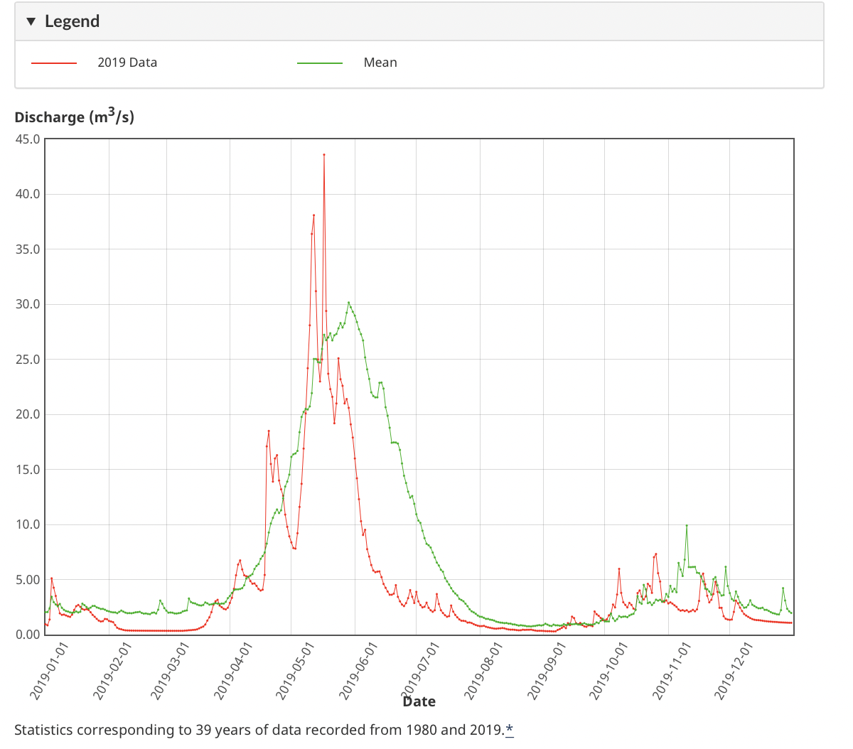
Historical flow data for the Tulameen River below Vuich Creek. 8cms will be a bare minimum, 15-20cms medium, and 30cms pretty high. Note that this gauge is on the Upper Tulameen section, while many paddlers are more familiar with the gauge Tulameen River at Princeton, which is at the takeout of the Lower (Classic) Tulameen and usually has at least twice as much flow as the upper gauge.


Description: Hike the Dewdney Trail into Tulameen Camp (about 15km) and put in on a low volume alpine creek that starts meandering through meadows with amazing views of Snass Peak and the surrounding mountains. Eventually, the river picks up speed and becomes a low volume, Class II/III creek with intermittent breaks in a few more meadows. Be on the lookout for a lot of wood in this section with many river wide logs blocking the narrow creek and a few beaver dams obstructing the flow. The crux of this section is a short canyon where Holding Creek enters the Tulameen. Two fun, clean Class III-IV entrance rapids lead into wood-choked class V rapid; in 2021 a massive piece of wood sat dead center of the runnable line and doesn’t appear to be going anywhere anytime soon. Portage river right either above the entrance rapids, or just below them if you’re confident running the entrance. Below this, the river widens and continues with Class II/III rapids to Horseguard Camp. There’s a bridge shortly below this canyon that could provide quick access to scout the canyon or an alternate takeout.


Falls - Horseguard Camp to Champion FSR Bridge Class II/III (P) ~15km
Levels & Gauge: This section hasn’t been run enough to have a 100% certainty in the gauge and level, but around 15 cms on the BELOW VUICH CREEK gauge seems to be a good medium-low level.


Description: A large campsite on the HBC brigade trail, Horseguard Camp provides easy beach access to the river and higher flows just below the confluence with Podunk Creek. The river quickly winds through classic Class II/III boogie water to the crux portage above Tulameen Falls. You know you’re getting close when you have to portage a massive log jam covering an entire island in a left hand river cover. Portage river left from the last beach on your left above the falls. Aim straight up towards a logging road on a ridge above and descend northeast off the nose of the ridge towards the Tulameen Falls trail. Hike upstream to put back in just below the falls. Below the falls, the river picks up a bit in a series of fun Class III pool drop rapids and Class II boogie water. Vuich Creek enters from river left, and has a runnable falls further upstream near the FSR.


Champion/Lodestone FSR Bridge to Olivine FSR Bridge Class III-IV (V+) ~5km
Levels & Gauge: Again, this section hasn’t been run enough to have a 100% certainty in the gauge and level. This stretch is a fun medium low between 8-15 cms on the BELOW VUICH CREEK gauge. Below this some of the more open sections might get too low, above it, expect the canyons to get pushier.


Fun class III leads into a beautiful Class III/IV canyon full of amazing, clean rapids. At medium to low levels, all the rapids have large recovery pools below, but could get more challenging at higher flows. Near the end of the canyon is a stout riverwide hole, and after a short open section, this is followed by a less runnable Class V (+?) constriction drop. Both drops can be portaged river right up and down some steep embankments. It may be possible to seal launch back into the canyon below the crux drop on river right, which would avoid a tiresome brushy portage. Wood could also become an issue in this canyon, so keep your head up.

%20constriction%20rapid%20at%20the%20end%20of%20the%20first%20canyon.jpg)
Olivine FSR to Tulameen Town (III-V) ~15km
Levels & Gauge: Again, this section hasn’t been run enough to have a 100% certainty in the gauge and level. This stretch is a fun medium low between 8-15 cms on the BELOW VUICH CREEK gauge. Below this and some of the rapids might get a little boney, above it, expect the rapids to get pushier and eddies to start to disappear.


Scenic Class III leads into a narrow Class V canyon about 1km below Illal/Britton Creek. Scouting and portaging this canyon is probably challenging at medium to high water. At low water, you can scout and portage at river level on river right, or portage along a flagged trail river left that takes you up to the Tulameen FSR. Look for pink flagging tape that directs you downstream, and orange flagging tape that climbs up towards the road. About 100m down the road, an old logging road descends right back to the river just below the crux and 200m upstream of an old cable car that runs above the river. From here it’s more pool drop Class III/IV until you hit another Class IV rapid with some serious wood hazard below a bridge (note, neither this bridge nor the roads serving it show up GPS or satellite images).


Lawless Creek confluences river left, but this area is private property and the creek itself is not worth paddling. Below this it’s more Class II-III until the valley opens up and the river eases towards the town of Tulameen. It’s mostly easy from here down, but one Class III rapid remains in a river right channel between two high banks. If it’s open, you can get food and beer at the Tulameen Trading Post.

,%20below%20this%20bridge%20is%20class%20II-III%20to%20Tulameen.jpg)
Classic/Lower - Tulameen to Princeton - II+ (IV) 28km (21km from Coalmont) (With files from Claudia Schwab)
Levels & Gauge: Runnable across a wide range of levels, around 80cms on the Princeton gauge is considered high. Still fun at lower levels around 15-20 cms.
Mostly a float with some Class II boogie water. The only major rapid is called either Tulameanie Drop, Tulameen Falls or Tunnel Rapid (depending on who you ask) but it’s all the same Class IV rapid with a Class III lead in section. Can be scouted at river level, or by hiking up to the KVR rail trail on river left, the rail trail also makes an easy portage. Take out on river right just past the Bridge of Dreams pedestrian bridge in Two Rivers Park. A new brewery is expected to open within walking distance of the takeout in 2022.
Granite Creek, which confluences river right below Coalmont, has some nice canyons but also a VERY dangerous mining adit in the river and is not recommended.